Monday, August 15, 2011
Carl's Jr in Los Angeles County
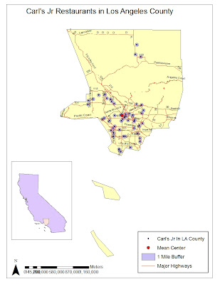
The map that I created illustrates 50 randomly chosen Carl's Jr restaurants in Los Angeles County. My first assumption was that the mean center of Carl's Jr would lie somewhere in the southeast region of the county. And as the map illustrates, the mean center is located almost at the heart of Downtown Los Angeles where the 10 and the 101 highways meet. I created a one mile buffer around the Carl's Jr restaurants to convey any overlaps or regions that have a higher concentration of Carl's Jr.
Geocoding is an important aspect of GIS. It enables an individual to conduct geospatial analyses and to determine whether there are geographic patterns in the specified region. Using ZIP code enables you to analyze the frequency of Carl's Jr in a specific location. All in all, geocoding is a useful tool when analyzing geospatial information
Below are the addresses of the randomly selected Carl's Jr Restaurants:
Subscribe to:
Post Comments (Atom)


No comments:
Post a Comment